
Geology of Land, Animals and Water
The Supercontinent of Fire, Water, and the Making of Victorian Country
MLA Educational Articles - Geology of Country
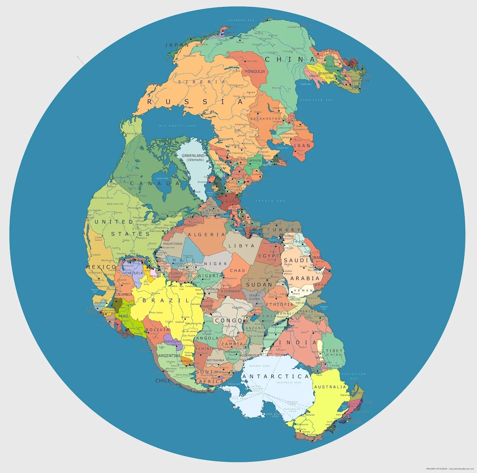
More than 300 million years ago, the face of the Earth looked completely different. All the world’s continents — Africa, South America, Antarctica, Australia, India, Europe, and North America — were joined together as one colossal landmass called Pangaea (Wegener, 1915; Scotese, 2015).
Pangaea, which existed from roughly 335 to 175 million years ago, was surrounded by the vast global ocean Panthalassa, and represented one of the greatest geological configurations in Earth’s deep-time history. It formed through the slow collision of earlier continents and eventually tore apart through powerful tectonic movement.
For modern scientists, Pangaea provides the key to understanding how continents move — a process known as plate tectonics — and why rocks, fossils, and landscapes on opposite sides of the world share such close similarities (Veevers, 2000). For Aboriginal people, whose cultural connection to Country reflects tens of thousands of years of continuity, the idea that all land was once united echoes an ancient truth — that Earth is one living body, constantly changing but always connected (Rose, 1996; Neale, 2017).
The Formation of Pangaea
The formation of Pangaea began in the Late Carboniferous Period, about 335 million years ago, when two large continental masses — Laurasia in the north and Gondwana in the south — collided (Scotese, 2015).
This event was driven by the movement of the Earth’s lithospheric plates, massive slabs of crust that slowly drift due to mantle convection — the heat-driven circulation of semi-molten rock deep beneath the surface (Condie, 2011). As the plates converged, they closed ancient oceans such as the Rheic and Iapetus, creating mountain ranges such as the Appalachians, Urals, and the Tasman Fold Belt (of which the Lachlan Fold Belt in Victoria is a part).
The supercontinent that emerged stretched nearly from pole to pole. In its southern half lay Gondwana, containing what is now Australia, Antarctica, India, Africa, and South America. The rest formed Laurasia, which included North America, Europe, and Asia.
Life and Climate on Pangaea
Pangaea’s vast size created extreme environmental contrasts. The interior regions were arid deserts, while coastal and southern high-latitude regions, such as what would become Victoria, were cooler and wetter (Scotese, 2015; Veevers, 2000).
Flora: Forests of ferns, seed ferns, and conifers dominated the landscape, forming the ancestors of modern southern vegetation.
Fauna: The late Palaeozoic and early Mesozoic saw the rise of amphibians, reptiles, and the earliest dinosaurs.
Oceans: Marine life thrived in Panthalassa, with ammonites, early fish, and corals developing new ecosystems.
Glacial deposits from this time, found across Australia, India, and South Africa, show that much of Gondwana lay near the South Pole, influencing the cool climates that shaped Victorian landscapes millions of years later (McGowran et al., 2004).
How Pangaea Formed Victoria’s Country
Although Victoria’s visible rocks are mostly younger than Pangaea, the geological structure and resources of Victoria were profoundly influenced by events that occurred during and after the age of the supercontinent.
1. The Lachlan Fold Belt and Gondwana’s Margin
During the late stages of Pangaea’s assembly and existence, Victoria lay on the eastern margin of Gondwana — a zone of intense subduction and volcanic activity (Joyce, 2010).
The Lachlan Fold Belt, which underlies most of Victoria, formed from marine sediments and volcanic arcs accreted onto Gondwana’s edge between 450–350 million years ago.
As Pangaea came together, these older belts were compressed and uplifted, laying down the metamorphic and granitic foundations of modern Victoria.
These rocks, visible today in the Grampians, You Yangs, and Macedon Ranges, record the immense tectonic pressures of Gondwana’s collision and Pangaea’s formation.
2. Mineral and Soil Legacy
The collision and folding of continental plates created deep crustal fractures that later allowed mineral-rich fluids to rise.
This process generated gold-bearing quartz veins, particularly in the Bendigo and Ballarat regions (VandenBerg et al., 2000).
Thus, Victoria’s 19th-century gold wealth can trace its geological origins back to the mountain-building events associated with Pangaea’s creation.
3. Post-Pangaean Sedimentation and Rift Basins
When Pangaea began to break apart during the Jurassic and Cretaceous Periods, new rift basins formed along what is now southern Victoria.
The Otway Basin and Gippsland Basin, both major features of Victoria’s geology, developed as rift valleys that opened when Australia began to separate from Antarctica (McGowran et al., 2004).
These basins collected sediments rich in organic matter, later forming the coal and petroleum reserves that sustain modern energy production in the state (Holdgate et al., 2003).
In this way, the breakup of Pangaea not only shaped Victoria’s physical geography — its mountains, plains, and coastlines — but also created the geological wealth that defined its modern history.
The Breakup of Pangaea
By about 200 million years ago, during the Early Jurassic, Pangaea began to fracture.
The causes were internal heat build-up and mantle convection currents generating rifting stress (Scotese, 2015).
Early Rift (200–180 Ma): Pangaea divided into Laurasia (north) and Gondwana (south).
Gondwana’s Breakup (180–100 Ma): Africa, India, and South America began to drift northward.
Australia’s Separation (85–45 Ma): Australia and Antarctica finally parted, leading to the formation of the Southern Ocean and the Antarctic ice cap (McGowran et al., 2004).
In Victoria, this movement triggered regional volcanic activity and sediment deposition. The land began to tilt and uplift, forming early versions of modern mountain systems and river networks.
Scientific Evidence for Pangaea
The theory of continental drift, proposed by Alfred Wegener in 1912, was initially met with scepticism, but later confirmed through plate tectonics. Evidence includes:
Fossils: Identical species (e.g. Glossopteris fern, Lystrosaurus reptile) found in South America, Africa, and Australia show these continents were once joined (Wegener, 1915).
Rock Formations: Matching mountain chains and rock sequences across Gondwana continents.
Palaeomagnetism: Magnetic patterns in ocean crust show symmetrical spreading from mid-ocean ridges.
Glacial Striations: Ice-scratched rocks in Victoria, Tasmania, and South Africa align towards a common ancient South Pole (Veevers, 2000).
Together, these data demonstrate that continents drifted over geological time, a principle that revolutionised Earth sciences.
Cultural Reflections and Connection to Country
For Aboriginal peoples, the Earth’s ancient transformations are expressed through creation stories, which understand land as a living, dynamic being.
In Wadawurrung and Gunditjmara Country, stories of Bunjil (the Eagle) and Budj Bim (the Volcano) describe how land and water were shaped by ancestral power.
While Pangaea is a geological narrative, it mirrors this worldview: that Country is constantly forming and reforming, bound together through story, spirit, and science (Rose, 1996; Neale, 2017).
Modern Earth science and Indigenous knowledge thus converge — both describing a living planet in motion, shaped by creation forces that connect all parts of the world.
Conclusion
The story of Pangaea is the story of Earth’s unity and transformation.
It reveals how continents move, how mountains rise and oceans form, and how these vast processes created the foundations of Victoria and Australia as we know them today.
From the compression of the Lachlan Fold Belt to the rifting of the Otway Basin, Pangaea’s formation and breakup wrote the earliest geological chapters of Victorian Country.
Through deep time and living story, it remains a reminder that the land beneath our feet is ancient — born of both fire and time, and still moving in the great rhythm of Earth’s life.
References
Condie, K. C. (2011) Earth as an Evolving Planetary System. Oxford: Academic Press.
Holdgate, G. R., Sluiter, I. R. & Kelman, A. P. (2003) ‘The origin of brown coal deposits in the Latrobe Valley, Victoria’, International Journal of Coal Geology, 54(1–2), pp. 77–99.
Joyce, E. B. (2010) The Western Victorian Volcanic Plains: A Field Guide to the Newer Volcanics Province. Geological Society of Australia.
McGowran, B., Li, Q., Cann, J. & Padley, D. (2004) ‘The Cenozoic of the Australian southern margin: evolution of a rifted continent’, Australian Journal of Earth Sciences, 51, pp. 125–145.
Neale, M. (2017) Songlines: The Power and Promise. Canberra: National Museum of Australia.
Rose, D. B. (1996) Nourishing Terrains: Australian Aboriginal Views of Landscape and Wilderness. Canberra: Australian Heritage Commission.
Scotese, C. R. (2015) Paleomap Project: Plate Tectonics and the Breakup of Pangaea. University of Texas.
VandenBerg, A. H. M., Willman, C. E. & Maher, S. (2000) Geology of Victoria. Geological Society of Australia, Special Publication 23.
Veevers, J. J. (2000) Gondwanaland from 650–500 Ma Assembly through 500 Ma Breakup: Its Impact on the Earth, Climate and Biosphere. Geological Society of Australia.
Wegener, A. (1915) The Origin of Continents and Oceans. Leipzig: Vieweg & Sohn.
Written, Researched and Directed by James Vegter (22 September 2025)
MLA
Sharing the truth of Indigenous and colonial history through film, education, land, and community.
www.magiclandsalliance.org
Copyright MLA – 2025
Magic Lands Alliance acknowledges the Traditional Owners, Custodians, and First Nations communities across Australia and internationally. We honour their enduring connection to the sky, land, waters, language, and culture. We pay respect to Elders past, present, and emerging, and to all First Peoples’ communities and language groups. This article draws only on publicly available information; many cultural practices remain the intellectual property of their respective communities.