
Bunurong/ Boonwurrung Place Names
Bunurong/Boonwurrung Sea Country, Lore of the Coast, and the Physics of Change at Yallock-Bulluk — Cape Paterson
MLA Educational Series — Bunurong/Boonwurrung Country: Water, Rock, and Spirit
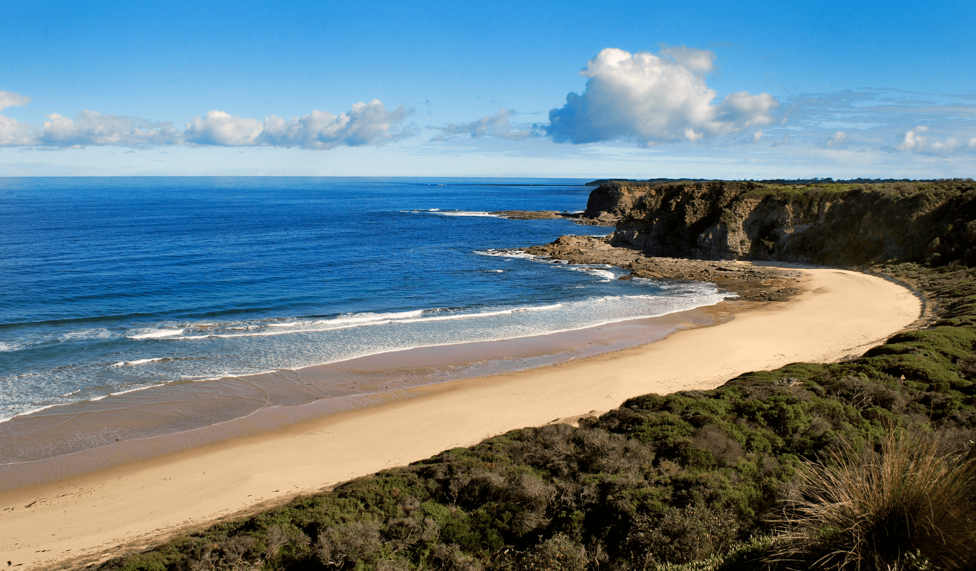
Along the wild southern coastline of Bunurong/Boonwurrung Country, where ocean swells breathe against ancient basalt and the wind carries stories older than memory, lies Yallock-Bulluk, known today as Cape Paterson. This shore, now within the Bunurong Marine National Park, is a sacred and scientific meeting place where deep-time geology, living marine ecologies, and cultural law converge. For Bunurong/Boonwurrung people, Yallock-Bulluk is a living relative — a place of teaching and ceremony holding balance between biik (land), warran (sea), and ngurrara (sky/law). Long before European naming, the cape and adjoining waters formed part of the Yallock-Bulluk clan estate — one of six Boonwurrung clans of the Kulin Nation (Clark & Heydon 2002; Bunurong Land Council Aboriginal Corporation 2023). Today the cape stands as both a globally significant palaeontological site and a living archive of Bunurong/Boonwurrung knowledge, where erosion, energy, and ecology align with Indigenous law.
The Meaning and Place of Yallock-Bulluk
In Boonwurrung language, yallock means “river” or “creek,” while bulluk denotes “people/group,” hence Yallock-Bulluk — “People of the River.” The name reflects enduring relationships with waterways that flow to Bunurong/Boonwurrung Sea Country, including the Powlett River (Kugerungmome) and small creeks that reach the coast near Cape Paterson and Harmers Haven (Blake 1991; Clark & Heydon 2002). Elders describe this Country as a breathing organism — “the place where the land breathes through water” — a view mirrored in hydrology, which reads the coast as a connected system of creeks, aquifers, dunes, and reefs.
Geology and Deep Time
The cliffs, platforms, and shore benches of Yallock-Bulluk expose Cretaceous sediments interlayered with younger basalts, formed through volcanic activity and long cycles of uplift and erosion (VandenBerg 1999). At nearby Flat Rocks (Inverloch), fossil discoveries since 1903 — including the small herbivorous Leaellynasaura amicagraphica — have made this coast internationally renowned (Rich & Vickers-Rich 1989). For Bunurong/Boonwurrung, these rocks are the bones of Country. Where geology speaks of tectonics and time, oral histories speak of Bunjil (eagle) and Waa (crow) shaping land and sea — distinct languages describing the same truth: memory is held in stone and tide.
Cultural Life Before Colonisation
For tens of thousands of years, Yallock-Bulluk was a seasonal gathering place and resource hub. Families camped behind dunes and tea-tree shelter, harvesting shellfish, fishing the reefs and inlets, and tending plant foods.
Marine food systems: Shell middens at Cape Paterson, Harmers Haven, and Inverloch contain layers of abalone, limpets, pipis, and mussels — evidence of long-term, sustainable coastal economies (Zola & Gott 1992; Presland 1994).
Freshwater knowledge: Springs and rock wells tucked behind dunes provided reliable supplies even in dry months, reflecting deep understanding of groundwater pathways.
Seaweed and fibre technologies: Brown kelp (Ecklonia radiata) and seagrasses were used for cooking, binding, and insulation — coastal engineering adapted to Bass Strait conditions (Gott & Zola 1992).
Navigation and observation: Star paths, coastal silhouettes, winds, currents, and bird behaviour informed travel and fishing — a maritime science grounded in careful, intergenerational observation.
These practices exemplify what ecology now terms adaptive resource management — behaviour aligned with cycles of tide, season, and species renewal.
Ecology and the Physics of the Coast
Cape Paterson sits within a high-energy wave climate. During storms, wave power along this coast can reach very high loads per metre of shoreline and drive rapid changes to beaches, reefs, and near-shore bars (DEECA 2023; Parks Victoria 2023). To Bunurong/Boonwurrung, this is not abstract “energy” but the breath of the sea. Ocean motion embodies the Law of Balance: waves cleanse and renew; tides feed and retreat; freshwater and marine flows find equilibrium. Coastal physics frames this as tidal flux, sediment transport, and dynamic equilibrium; Elders describe it as “the sea thinking with the land.” Both readings converge on the same insight — health emerges from flow and reciprocity.
Colonial Naming and Dispossession
The name “Cape Paterson” was given in 1801 by Lieutenant James Grant aboard the Lady Nelson, honouring Lieutenant-Colonel William Paterson (Cannon 1981). For settlers it marked discovery; for Bunurong/Boonwurrung it marked erasure. By the 1840s, pastoral expansion, maritime industries, and later coal extraction transformed Country. The Wonthaggi coalfields and coastal lime works damaged middens and sacred places; pollution and habitat loss followed. Frontier conflict and removals pushed families toward places like Mordialloc and Coranderrk (Barwick 1998; Broome 2005). Despite this, stories and law endured: never take more than the tide gives.
Truganini and the Sea of Passage
In the 1840s, Truganini, a Nuenonne woman from lutruwita/Tasmania, travelled through Western Port and the Bass Coast, including country near Cape Paterson and Inverloch. Her journey recalls older connections across the Bassian Land Bridge, which linked Tasmania and Victoria before sea levels rose ~8,000 years ago — a pathway held in the oral histories of Tasmanian and Bunurong/Boonwurrung peoples (Ryan 2012; Bunurong Land Council Aboriginal Corporation 2023). Yallock-Bulluk thus stands at the intersection of geological change and enduring cultural continuity.
Environmental and Cultural Restoration
Today, Yallock-Bulluk / Cape Paterson forms part of the Bunurong Marine National Park, managed by Parks Victoria in partnership with the Bunurong Land Council Aboriginal Corporation (BLCAC) and DEECA. Key initiatives include:
Protection of intertidal/subtidal habitats — kelp forests, sponge gardens, and reef fish communities.
Conservation of fossil beds and midden sites under state heritage frameworks.
Cultural mapping and dual-naming that restore Bunurong/Boonwurrung language to signs and educational programs.
Community education integrating Traditional Ecological Knowledge with marine science (BLCAC 2023; Parks Victoria 2023).
Dune stabilisation and re-planting of native coastal vegetation to curb erosion and rebuild biodiversity.
These actions reflect the principle biik-Bunurong wurrung-gi — Country and language heal together.
Law of Motion: Cultural Physics and Coastal Energy
Across Indigenous law and environmental science, energy and matter are always moving. Bunurong/Boonwurrung Law of Flow mirrors the physical concept of dynamic equilibrium: systems live through change, not stasis. At Yallock-Bulluk, tides are both spiritual and physical rhythms:
Spiritually, they cleanse and renew — a law given by Bunjil that maintains right relation between people and sea.
Physically, they drive nutrient cycling, oxygen exchange, larval dispersal, and sediment patterns that sustain coastal life.
To “read” the ocean is to engage with its intelligence; the waves themselves are teachers.
Conclusion
Yallock-Bulluk (Cape Paterson) is where time, culture, and energy converge. For Bunurong/Boonwurrung, it remains a living classroom; for scientists and conservationists, a key site for geological and ecological study. Together, these perspectives affirm a shared truth: Country is a relationship, not a resource. In every tide and every stone of Yallock-Bulluk, the law of balance endures — reminding all who visit that the spirit of the sea still breathes beneath the waves.
References
Barwick, D. (1998) Rebellion at Coranderrk. Canberra: Aboriginal History Monograph.
Blake, B. (1991) Wathawurrung and the Colac Language of Southern Victoria. Canberra: Pacific Linguistics.
Broome, R. (2005) Aboriginal Victorians: A History Since 1800. Sydney: Allen & Unwin.
Bunurong Land Council Aboriginal Corporation (2023) Bunurong Sea Country and Cultural Water Plan. Melbourne: BLCAC.
Cannon, M. (1981) Life in the Country: Australia in the Victorian Age, 1840–1890. Melbourne: Nelson.
Clark, I.D. & Heydon, T. (2002) Dictionary of Aboriginal Placenames of Victoria. Melbourne: Victorian Aboriginal Corporation for Languages.
DEECA Victoria (2023) Marine and Coastal Policy — Bunurong Marine National Park. Melbourne: Department of Energy, Environment and Climate Action.
Parks Victoria (2023) Bunurong Marine and Coastal Parks Management Plan. Melbourne: State Government of Victoria.
Presland, G. (1994) Aboriginal Melbourne: The Lost Land of the Kulin People. Melbourne: Harriland Press.
Rich, T. & Vickers-Rich, P. (1989) Dinosaurs of Darkness. Sydney: Doubleday.
Ryan, L. (2012) Tasmanian Aborigines: A History Since 1803. Sydney: Allen & Unwin.
VandenBerg, A.H.M. (1999) Geology of Victoria. Geological Society of Australia, Special Publication 10.
Zola, N. & Gott, B. (1992) Koorie Plants, Koorie People: Traditional Aboriginal Food, Fibre and Healing Plants of Victoria. Melbourne: Koorie Heritage Trust.
Written, Researched and Directed by James Vegter (22 September 2025)
MLA
Sharing the truth of Indigenous and colonial history through film, education, land, and community.
www.magiclandsalliance.org
Copyright MLA – 2025
Magic Lands Alliance acknowledges the Traditional Owners, Custodians, and First Nations communities across Australia and internationally. We honour their enduring connection to the sky, land, waters, language, and culture. We pay respect to Elders past, present, and emerging, and to all First Peoples’ communities and language groups. This article draws only on publicly available information; many cultural practices remain the intellectual property of their respective communities.