
Bunurong/ Boonwurrung Place Names
Bay of Winds, Stories, and the Law of the Shore
MLA Educational Series — Bunurong/Boonwurrung Country: Nairm, Water, and the Spirit of Place
Where the waters of Nairm (Port Phillip Bay) meet the sandy curve of Melbourne’s inner coast lies Euro-Yroke, known today as St Kilda. This stretch of coastline, defined by its tides, winds, and shifting sands, sits within the traditional lands of the Bunurong/Boonwurrung people of the Kulin Nation. Their presence along these shores reaches back tens of thousands of years (Broome 2005; Clark & Heydon 2002).
For the Bunurong/Boonwurrung, Euro-Yroke was far more than a beach. It was a living meeting ground between freshwater and saltwater, a threshold where social, spiritual, and ecological networks converged. It was a place for ceremony, trade, and story — where the rhythm of the sea expressed the Law of Balance that guides all life on Country.
The Meaning of Euro-Yroke
The name Euro-Yroke (pronounced Yir-ra-yoke) comes from the Bunurong/Boonwurrung language and is often interpreted as “the grinding stone” or “the red stone place.” Early records suggest it refers to the red sandstone cliffs and ochre deposits once common along the St Kilda and Elwood foreshores (Clark & Heydon 2002). These materials were used for tool-making, trade, and body decoration.
In Bunurong/Boonwurrung law, the grinding stone symbolises transformation — the act of turning raw material into nourishment. This meaning mirrors the ocean’s constant shaping of the shore, where every wave wears and remakes the land. The name also reflects a deeper idea: that language, landscape, and law are inseparable. Each word carries the sound and story of its place, linking people to the Country they belong to.
Geology and the Shape of the Bay
The St Kilda coastline forms part of the Nairm embayment, created about 6,000 years ago when rising seas flooded ancient river valleys after the last Ice Age (VandenBerg 1999). Before this inundation, the Yarra and Maribyrnong Rivers wound through a wide grassy plain that extended far south toward what is now Bass Strait. When sea levels rose, the great land bridge to Tasmania disappeared, and the new bay became an inland sea enclosed by dunes and wetlands.
Bunurong/Boonwurrung oral traditions remember this transformation. Stories speak of the sea “coming up to claim the plain,” echoing modern geological accounts of post-glacial sea-level rise (Broome 2005). The dunes, lagoons, and estuaries that later formed at Euro-Yroke supported a rich web of life — from eels and shellfish to swans and native reeds — providing food, materials, and spiritual lessons about adaptation and renewal.
Cultural Life at the Edge of Nairm
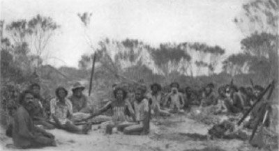
For countless generations, Euro-Yroke served as a seasonal gathering place for Bunurong/Boonwurrung families. Archaeological evidence of campsites, shell middens, and stone tools — especially near Elwood Canal and the St Kilda Botanical Gardens — attests to thousands of years of continuous occupation (Presland 1994). Families camped near freshwater springs that bubbled through the dunes, fished from rocky points, and collected shellfish, seaweed, and edible roots along the foreshore.
The area was also a significant ceremonial and diplomatic ground. The Ngargee Biik, or ceremonial land near modern Albert Park, hosted corroborees, marriages, and trade gatherings involving the Wurundjeri and Wathaurong peoples (Clark 1990; Barwick 1998). These meetings reinforced kinship and the reciprocal obligations that maintained harmony across the Kulin Nation.
In Bunurong/Boonwurrung cosmology, Nairm was a living being — Biik Boorron, “the body of Country.” The tides and winds were the breath of Bunjil, the creator eagle, and Waa, the crow messenger. Every tide carried both nourishment and warning, teaching that balance must be maintained through respect and restraint.
Colonial Settlement and Transformation
European occupation began in the 1830s, when the Port Phillip District expanded southward. The area soon became prized for its open grasslands and proximity to Melbourne. Wetlands were drained, creeks channelled, and dunes flattened to make way for streets and seaside villas. By the 1850s, St Kilda had become a fashionable resort, its natural systems reshaped for leisure and commerce (Cannon 1981).
For the Bunurong/Boonwurrung, this development brought dispossession and cultural rupture. Access to traditional fishing grounds and freshwater sites was cut off, and the ceremonial gatherings that once animated the bay were forbidden. Many were relocated to missions at Mordialloc and Coranderrk, though some families continued to visit the coast in secret, maintaining connection through language, song, and memory (Broome 2005).
The name “St Kilda,” taken from a visiting schooner, replaced Euro-Yroke on colonial maps. Yet the original spirit of the place — its identity as a site of transformation — endured beneath the urban landscape, preserved in story and the unceasing rhythm of the tide.
Ecology and the Physics of the Bay
St Kilda lies within one of Victoria’s most dynamic estuarine environments. The tidal exchange between Nairm and the Yarra River estuary creates a shifting gradient of salt and fresh water that supports mangroves, seagrass meadows, and migratory birds. Hydrological modelling estimates that each tide moves more than two billion litres of water through the lower bay (DEECA 2023).
For the Bunurong/Boonwurrung, these changes were read through careful observation rather than instruments. The colour of the water showed the balance between salt and fresh; the calls of seabirds indicated shifts in season; and the direction of the wind revealed the moods of the spirits that governed the bay. This form of empirical knowledge, refined over millennia, is now recognised by modern science as a sophisticated system of environmental monitoring and management.
Cultural Renewal and Modern Recognition
Today, Euro-Yroke is acknowledged as a place of living heritage under the care of the Bunurong Land Council Aboriginal Corporation (BLCAC). Collaborative projects with Parks Victoria, the City of Port Phillip, and DEECA integrate Indigenous ecological knowledge into coastal restoration and education (BLCAC 2023).
Revegetation programs are returning native dune plants such as coastal tea-tree, pigface, and spinifex, stabilising the foreshore and improving habitat for migratory birds. Educational initiatives introduce Bunurong/Boonwurrung place-names alongside colonial ones, and school programs teach tidal reading, language, and sustainable resource use.
Through these projects, Euro-Yroke is regaining its voice. The return of Indigenous names and stories to the shoreline is not symbolic — it is ecological, cultural, and ethical restoration working in unison.
Conclusion
Euro-Yroke, the place known as St Kilda, is a landscape of continuity beneath change. Its name — “the grinding stone” — evokes the slow, rhythmic shaping that defines both geology and human experience. From its red cliffs and shifting tides to the hum of city life above it, the Country still speaks of transformation and resilience.
For the Bunurong/Boonwurrung, this coastline remains part of an unbroken network of Sea Country that connects Nairm, Western Port, and the open ocean. For all Victorians, it stands as a reminder that beneath every urban space lies an older rhythm waiting to be heard. When people learn again to listen to that rhythm, the land and water find balance — and so do we.
References
Barwick, D. (1998) Rebellion at Coranderrk. Canberra: Aboriginal History Monograph.
Blake, B. (1991) Wathawurrung and the Colac Language of Southern Victoria. Canberra: Pacific Linguistics.
Broome, R. (2005) Aboriginal Victorians: A History Since 1800. Sydney: Allen & Unwin.
Bunurong Land Council Aboriginal Corporation (2023) Caring for Sea Country: Bunurong Coastal Management Plan. Melbourne: BLCAC.
Cannon, M. (1981) Life in the Country: Australia in the Victorian Age, 1840–1890. Melbourne: Nelson.
Clark, I.D. (1990) Aboriginal Languages and Clans: An Historical Atlas of Western and Central Victoria, 1800–1900. Melbourne: Monash Publications in Geography.
Clark, I.D. & Heydon, T. (2002) Dictionary of Aboriginal Placenames of Victoria. Melbourne: Victorian Aboriginal Corporation for Languages.
DEECA Victoria (2023) Port Phillip Bay Environmental and Cultural Water Policy. Melbourne: Department of Energy, Environment and Climate Action.
Presland, G. (1994) Aboriginal Melbourne: The Lost Land of the Kulin People. Melbourne: Harriland Press.
VandenBerg, A.H.M. (1999) Geology of Victoria. Geological Society of Australia, Special Publication 10.
Zola, N. & Gott, B. (1992) Koorie Plants, Koorie People: Traditional Aboriginal Food, Fibre and Healing Plants of Victoria. Melbourne: Koorie Heritage Trust.
Written, Researched and Directed by James Vegter (22 September 2025)
MLA
Sharing the truth of Indigenous and colonial history through film, education, land, and community.
www.magiclandsalliance.org
Copyright MLA – 2025
Magic Lands Alliance acknowledges the Traditional Owners, Custodians, and First Nations communities across Australia and internationally. We honour their enduring connection to the sky, land, waters, language, and culture. We pay respect to Elders past, present, and emerging, and to all First Peoples’ communities and language groups. This article draws only on publicly available information; many cultural practices remain the intellectual property of their respective communities.