
Bunurong/ Boonwurrung Place Names
Gateway of Land, Sea, and Law
MLA Educational Series — Bunurong/Boonwurrung Country: Coastlines, Currents, and the Law of the Edge
At the narrow tip of the Mornington Peninsula, where the calm waters of Nairm (Port Phillip Bay) meet the roaring swells of Bass Strait, lies Monmar — known in colonial records as Point Nepean.
This striking landscape of limestone cliffs, dunes, and coastal scrub forms the southwestern edge of Bunurong/Boonwurrung Sea Country, a place of immense cultural, spiritual, and ecological significance. To the Bunurong/Boonwurrung peoples, Monmar is not just a physical headland but a gateway — the threshold between two worlds: the still, sheltered waters of the bay and the deep, breathing ocean beyond (Clark & Heydon 2002; Bunurong Land Council Aboriginal Corporation 2023). Here, the forces of wind, tide, and current converge in perpetual dialogue. For countless generations, Monmar has stood as a site of ceremony, navigation, and story — a living expression of the Bunurong/Boonwurrung Law of Balance that connects land, sea, and sky.
The Meaning of Monmar
The name Monmar (also recorded as Mon mar or Monmarung) originates from the Bunurong/Boonwurrung language of the Kulin Nation. Early sources suggest it refers to “the neck of land,” “the headland,” or “the place of the channel,” describing the peninsula’s narrow connection between bay and ocean (Blake 1991; Clark & Heydon 2002). For the Bunurong/Boonwurrung, Monmar is a lore boundary — a place of passage where the spirit of the sea (Warran) meets the spirit of the land (Biik). The headland was understood as both dangerous and sacred. The strong currents and rip tides of The Rip, the narrow entrance to Port Phillip, were seen as the physical embodiment of energy exchange — what Indigenous philosophy calls Ngurrara, the balance between opposing forces (Broome 2005). The name “Monmar” therefore holds more than geography; it speaks to lore and identity. It reminds all who stand there that boundaries in Country are never divisions, but relationships between energies in motion.
Geology and the Ancient Coastline
The Mornington Peninsula and Point Nepean are the products of deep geological processes that have shaped Victoria’s coastline for millions of years. The cliffs and dunes are composed primarily of limestone and sandstone deposited during the Neogene Period, between 25 and 2 million years ago (VandenBerg 1999). Over time, shifting sea levels, tectonic uplift, and wind erosion carved the peninsula into its present form — a long, tapering arm of land guarding the entrance to Port Phillip Bay.
For the Bunurong/Boonwurrung, these geological movements are remembered through story. Oral traditions speak of Bunjil, the creator, and Waa, the messenger crow, shaping the land and setting the boundaries of sea and sky. In these narratives, the sea’s advance and retreat mirror cycles of creation and renewal — a reflection of the scientific understanding of post-glacial sea-level rise.
The result is one of Australia’s most dynamic coastal environments: shifting dunes, tidal channels, and headlands that breathe with the rhythm of the ocean. This constant motion is both the physical and spiritual essence of Monmar — a landscape that never stops changing, yet never ceases to be whole.
Indigenous Life and the Law of the Coast
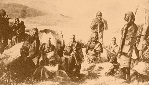
Before colonisation, the Mornington Peninsula was home to the Yallock-Bulluk and Mayune-Bulluk clans of the Bunurong/Boonwurrung Nation, whose Country extended across Nairm, Western Port, and the southern coast to Cape Schanck and beyond (Clark 1990; Broome 2005). Monmar was a key site for ceremony, navigation, and resource collection. The surrounding waters were rich in fish, shellfish, and seaweed, while the dunes and creeks provided freshwater and seasonal plants such as murnong (yam daisy), saltbush, and coastal berries (Zola & Gott 1992; Presland 1994). Campsites, middens, and artefact scatters found along the coast record thousands of years of continuous occupation. The area also served as a ceremonial crossing point — where messengers from the Wathaurong and Gunai/Kurnai Nations could meet under protocols of law and exchange. Songlines followed the coastline, connecting Monmar to other sacred coastal sites such as Cape Schanck (Tunnahan) and Point Leo (Karrum Karrum). In Bunurong/Boonwurrung cosmology, Monmar represents the “edge of vision” — a place where people come to learn humility before the vastness of the sea. The headland’s high winds and shifting sands teach patience, respect, and awareness — qualities that remain central to cultural practice today.
Colonial Contact and Displacement
The Mornington Peninsula was among the first regions of Victoria to experience sustained European intrusion. In 1801, British explorer Lieutenant James Grant sailed through the Heads aboard the Lady Nelson, naming the site “Point Nepean” after the British politician Sir Evan Nepean (Cannon 1981). This act of naming marked the beginning of dispossession. Within a few decades, settlers and pastoralists had occupied much of the peninsula, disrupting the seasonal patterns and sacred connections that had defined Bunurong/Boonwurrung life for millennia. By the 1830s and 1840s, violence, disease, and displacement had devastated local populations. Many survivors were forced onto missions at Mordialloc and Coranderrk, while others continued to move through the coastal plains, maintaining connection through story and ceremony (Barwick 1998; Broome 2005). The headland itself was soon transformed into a site of fortification and quarantine. Fort Nepean, established in the 1880s, and the Quarantine Station at Point Nepean became key components of colonial defence and health policy. Yet beneath these layers of stone and concrete, the old Country remained alive. The dunes and cliffs continued to erode and rebuild, whispering the same law of impermanence that had guided the Bunurong/Boonwurrung since time immemorial.
Ecology and the Physics of the Edge
The environment of Monmar is one of Australia’s most dynamic coastal systems. The powerful tidal exchange through The Rip — the entrance to Port Phillip Bay — creates one of the most turbulent marine zones in the Southern Hemisphere. Hydrological studies show tidal flows exceeding 5 knots, transferring vast volumes of water between the bay and the ocean twice daily (DEECA 2023). For Indigenous people, this movement was interpreted as the breath of Country — the ocean exhaling and inhaling life. The cliffs, dunes, and reefs acted as natural laboratories of balance. Every current, wind, and tide carried information about the seasons, the fish, and the health of the land. In this way, Monmar represents both an ecological and philosophical frontier. It is where physics meets story — where scientific observation and spiritual insight describe the same truth: energy is cyclical, and life depends on flow.
Cultural Continuity and Modern Restoration
Today, Monmar and the broader Mornington Peninsula form part of the Point Nepean National Park and are recognised as a key cultural landscape managed in partnership with the Bunurong Land Council Aboriginal Corporation (BLCAC), Parks Victoria, and DEECA. This collaboration integrates Traditional Knowledge into park management, ecological monitoring, and public education. Programs include cultural site mapping, Bunurong/Boonwurrung language signage, and youth ranger training that teaches traditional navigation, seasonal understanding, and ceremony (BLCAC 2023). Restoration efforts also focus on the recovery of coastal vegetation — moonah woodlands, spinifex dunes, and salt-tolerant shrubs — which stabilise the landscape and support threatened species such as the hooded plover and swamp antechinus. These projects bring together science and culture under the same principle: to restore balance through respect for the natural order. Monmar once marked a boundary between land and sea; today, it marks a partnership between knowledge systems — Indigenous and scientific — working together to protect Country.
Conclusion
Monmar — the place now known as Point Nepean — remains a powerful symbol of connection, change, and endurance. It is the meeting point of worlds: calm bay and open ocean, ancient story and modern science, destruction and renewal. For the Bunurong/Boonwurrung, Monmar is not merely a site of the past but a teacher for the future — a living classroom where the Law of Balance continues to be expressed through the tides, winds, and cliffs of the peninsula. As the waves carve and reshape the land, they remind all who stand upon it that Country is never fixed. It breathes, shifts, and remembers.
Through shared care and truth-telling, Monmar once again becomes what it always was — a gateway of understanding between people and the living world.
References
Barwick, D. (1998) Rebellion at Coranderrk. Canberra: Aboriginal History Monograph.
Blake, B. (1991) Wathawurrung and the Colac Language of Southern Victoria. Canberra: Pacific Linguistics.
Broome, R. (2005) Aboriginal Victorians: A History Since 1800. Sydney: Allen & Unwin.
Bunurong Land Council Aboriginal Corporation (2023) Bunurong Sea Country and Cultural Water Plan. Melbourne: BLCAC.
Cannon, M. (1981) Life in the Country: Australia in the Victorian Age, 1840–1890. Melbourne: Nelson.
Clark, I.D. (1990) Aboriginal Languages and Clans: An Historical Atlas of Western and Central Victoria, 1800–1900. Melbourne: Monash Publications in Geography.
Clark, I.D. & Heydon, T. (2002) Dictionary of Aboriginal Placenames of Victoria. Melbourne: Victorian Aboriginal Corporation for Languages.
DEECA Victoria (2023) Marine and Coastal Policy: Point Nepean and Port Phillip Bay. Melbourne: Department of Energy, Environment and Climate Action.
Parks Victoria (2023) Point Nepean National Park Management Plan. Melbourne: State Government of Victoria.
Presland, G. (1994) Aboriginal Melbourne: The Lost Land of the Kulin People. Melbourne: Harriland Press.
VandenBerg, A.H.M. (1999) Geology of Victoria. Geological Society of Australia, Special Publication 10.
Zola, N. & Gott, B. (1992) Koorie Plants, Koorie People: Traditional Aboriginal Food, Fibre and Healing Plants of Victoria. Melbourne: Koorie Heritage Trust.
Written, Researched and Directed by James Vegter (22 September 2025)
MLA
Sharing the truth of Indigenous and colonial history through film, education, land, and community.
www.magiclandsalliance.org
Copyright MLA – 2025
Magic Lands Alliance acknowledges the Traditional Owners, Custodians, and First Nations communities across Australia and internationally. We honour their enduring connection to the sky, land, waters, language, and culture. We pay respect to Elders past, present, and emerging, and to all First Peoples’ communities and language groups. This article draws only on publicly available information; many cultural practices remain the intellectual property of their respective communities.