
Bunurong/ Boonwurrung Place Names
Water Law, Ecology, and the Physics of Flow at Kugerungmome — Powlett River
MLA Educational Series — Sea Country and River Systems of South-Eastern Victoria
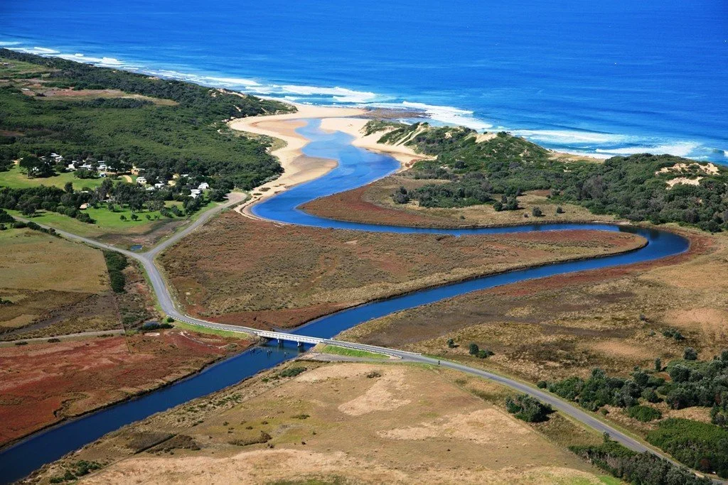
The Powlett River, known to the Bunurong (Boonwurrung) people as Kugerungmome, runs from the southern Strzelecki foothills to its tidal mouth near Wonthaggi, where it meets the swells of Bass Strait. For Bunurong, the river is a law-place and lifeline where freshwater and saltwater, land and sea, spirit and science move in balance (BLCAC, 2023; Broome, 2005). In language records, Kugerungmome is linked to “fish water/blackfish place,” reflecting once-abundant blackfish and eels (kooyang) central to food, ceremony, and exchange (Clark & Heydon, 2002; Zola & Gott, 1992).
Cultural geography and meaning
The catchment of Kugerungmome spans forested headwaters, floodplains, and a tidal estuary—an integrated part of Bunurong Sea Country, where land health and ocean health are inseparable (BLCAC, 2023). In Bunurong cosmology, water is connective spirit: spring-fed creeks carry life from uplands; the estuary is a meeting of worlds symbolising renewal and balance. Elders describe the river as “the artery that feeds Country,” a teaching mirrored in modern watershed science (DEECA, 2023).
Country before colonisation
Prior to invasion, Kugerungmome supported thriving wetland and estuarine ecologies: black swans (kunuwarra), pelicans, and migratory shorebirds; kooyang, blackfish, and freshwater mussels; and reedbeds harvested for rope, baskets, and nets (Zola & Gott, 1992; Presland, 1994). Eel migrations timed by moon and tide drew Bunurong and neighbouring Kulin clans for tanderrum—welcomes that enabled trade, marriage, and teaching—an observational science of seasons long before European hydrology (Broome, 2005).
The physics of flow and Indigenous knowledge
Kugerungmome’s gentle gradient delivers low-velocity flows that deposit sediment, build floodplains, and maintain wetlands—what hydrology terms flow balance and sediment transport (DEECA, 2023). Bunurong law frames the same reality as rhythm and respect: water “finds its own thinking,” distributing nutrients and sustaining habitats when unimpeded. At the mouth, tidal exchange from Bass Strait oxygenates waters and creates salinity stratification vital for fish, invertebrates, and aquatic plants (WGCMA, 2023). Traditional observations—“when tides breathe clean and strong, fish return”—anticipate modern measures of dissolved oxygen and connectivity.
Ecology and environmental systems
Along its length, the river grades through distinct yet connected zones:
Headwaters: spring-fed creeks shaded by paperbark and blackwood stabilise temperatures and provide refuges for blackfish and mussels.
Mid-catchment floodplains: reedbeds slow water, trap sediments, and offer habitat for birds and amphibians.
Estuary: tidal mixing supports saltmarsh and mangrove communities, acting as nurseries for estuarine fish (DEECA, 2023; WGCMA, 2023).
Bunurong principles of biik (land), warran (sea), ngurrung (air/wind) as one system align with the hydrological continuum recognised by contemporary ecology (BLCAC, 2023; DEECA, 2023).
Traditional water management and cultural engineering
Bunurong people managed Kugerungmome through precise, low-impact interventions: cool burns to open choked reedbeds; brush or stone structures that guided (not blocked) migrating fish; and seasonal limits ensuring kooyang cycles remained strong (Zola & Gott, 1992; Presland, 1994). These practices reflect an applied understanding of flow dynamics, energy transfer, and population sustainability—concepts at the core of river restoration today.
Colonial disruption and change
From the 1840s, clearing and grazing accelerated erosion and siltation; drains and levees altered flooding; stock trampled banks; and uncontrolled hunting reduced waterbird populations (Broome, 2005). These were ecological losses and breaches of law: damage to an ancestor river and the kin relations it sustains (BLCAC, 2023).
Restoration and modern Indigenous science
Partnerships between the West Gippsland Catchment Management Authority (WGCMA) and Bunurong Land Council Aboriginal Corporation (BLCAC) now guide recovery efforts: riparian revegetation; monitoring of salinity–oxygen dynamics alongside traditional indicators (eel runs, bird arrivals); managed estuary openings to restore tidal flushing; and cultural mapping of fishing and ceremony places to prioritise protection and education (WGCMA, 2023; BLCAC, 2023; DEECA, 2023). The approach treats Traditional Knowledge and Western science as complementary evidence streams.
Cultural physics and the law of flow
Both Bunurong law and physics teach that water seeks equilibrium. When interference breaks balance, systems respond—flood, drought, collapse—echoing feedback and resilience theory. The estuary’s mixing of fresh and salt is a living engine of energy exchange and a material metaphor for reciprocity: take only what is needed, give back through care, allow time for renewal (BLCAC, 2023).
Modern recognition and continuity
Dual naming—Powlett River / Kugerungmome—restores voice and signals ongoing sovereignty. Through language revival, on-Country learning, and catchment projects, Bunurong communities teach that water is kin: it breathes, moves, and remembers (BLCAC, 2023).
Conclusion
Kugerungmome is a teacher of balance. Its flow carries ancestral law and the patterns of physics—the same forces that shape wind, tide, and life. Restoring the river renews the relationship between people and Country—between science and spirit, history and healing—so that, like fresh and salt at the mouth, past and future meet in living water.
References
Barwick, D. (1998) Rebellion at Coranderrk. Canberra: Aboriginal History Monograph.
Blake, B. (1991) Wathawurrung and the Colac Language of Southern Victoria. Canberra: Pacific Linguistics.
Broome, R. (2005) Aboriginal Victorians: A History Since 1800. Sydney: Allen & Unwin.
Bunurong Land Council Aboriginal Corporation (2023) Cultural Water and Sea Country Plan. Melbourne: BLCAC.
Cannon, M. (1981) Life in the Country: Australia in the Victorian Age, 1840–1890. Melbourne: Nelson.
Clark, I.D. & Heydon, T. (2002) Dictionary of Aboriginal Placenames of Victoria. Melbourne: VACL.
DEECA Victoria (2023) Victorian Water and Cultural Heritage Policy and Coastal/Estuary Guidance. Melbourne: State of Victoria.
Gott, B. & Zola, N. (1992) Koorie Plants, Koorie People: Traditional Aboriginal Food, Fibre and Healing Plants of Victoria. Melbourne: Koorie Heritage Trust.
Presland, G. (1994) Aboriginal Melbourne: The Lost Land of the Kulin People. Melbourne: Harriland Press.
West Gippsland Catchment Management Authority (2023) Powlett River / Kugerungmome Partnerships: Strategic Directions. Traralgon: WGCMA.
Written, Researched and Directed by James Vegter (22 September 2025)
MLA
Sharing the truth of Indigenous and colonial history through film, education, land, and community.
www.magiclandsalliance.org
Copyright MLA – 2025
Magic Lands Alliance acknowledges the Traditional Owners, Custodians, and First Nations communities across Australia and internationally. We honour their enduring connection to the sky, land, waters, language, and culture. We pay respect to Elders past, present, and emerging, and to all First Peoples’ communities and language groups. This article draws only on publicly available information; many cultural practices remain the intellectual property of their respective communities.